


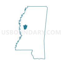
Gooden Lake Voting District, Humphreys County, Mississippi
About
Outline

Summary
| Unique Area Identifier | 605672 |
| Name | Gooden Lake Voting District |
| County | Humphreys County |
| State | Mississippi |
| Area (square miles) | 20.87 |
| Land Area (square miles) | 20.71 |
| Water Area (square miles) | 0.16 |
| % of Land Area | 99.21 |
| % of Water Area | 0.79 |
| Latitude of the Internal Point | 33.15002540 |
| Longtitude of the Internal Point | -90.64926700 |
Maps


Graphs
Select a template below for downloading or customizing gragh for Gooden Lake Voting District, Humphreys County, Mississippi


Neighbors
Neighoring Voting District (by Name) Neighboring Voting District on the Map
- Darlove Baptist Church Voting District, Washington County, MS
- Hollandale City Hall Voting District, Washington County, MS
- Isola Voting District, Humphreys County, MS
- Midnight Voting District, Humphreys County, MS
Top 10 Neighboring County Subdivision (by Population) Neighboring County Subdivision on the Map
- District 5, Washington County, MS (9,476)
- District 2, Humphreys County, MS (1,903)
- District 5, Humphreys County, MS (1,813)